Watch this video to learn more
Airspace Link's FlySafe Program, powered by AirHub®
How Ontario, CA Became Drone Ready
Through its partnership with Airspace Link's FlySafe Program for drone integration and management, the City of Ontario, California, has emerged as a U.S. leader in urban air mobility planning and drone readiness. Watch this video to learn how.
Ontario's Story: Setting the Pace for Drone Readiness
The City of Ontario, California, is leading the way in achieving drone readiness and planning for new urban air mobility applications through Airspace Link’s FlySafe Program.
Recognizing drones' potential but aware of regulatory barriers, Ontario enlisted Airspace Link's expertise in municipal drone integration, leveraging the FlySafeProgram’s turnkey stepped approach. Since its introduction, Ontario gained critical tools and training to safely harness the potential of drones and introduce coordinated drone activity into the community, implementing pilot drone initiatives across public safety, infrastructure inspection, and product delivery, with an eye on expanded services like a recreational drone park and on-demand cargo delivery zones that will help attract additional economic development.
With the FlySafe Program, powered by AirHub®, Ontario has become a national model for U.S. communities seeking to unlock the unlimited potential of a vibrant city drone ecosystem.

AirHub® Portal
Uniting the Skies, Streamlining Workflows
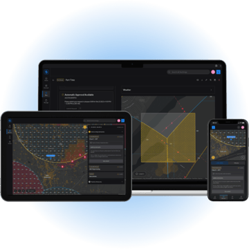
Ontario is powering its drone innovation through Airspace Link's AirHub® Portal, which incorporates mapping data from Esri, the leading geographic information systems (GIS) company. AirHub® Portal maps airspace to identify safe and unsafe flight areas while enabling Ontario to authorize drone flights with the FAA in real time. Through AirHub® Portal's geospatial analysis displays, the city can monitor approved flight paths and air traffic, track individual drone flights, and enhance their planning, operating, and administrative workflows to enable safe drone operations in the National Airspace and communities at scale.
Importantly, Airspace Link is fully integrated with the FAA and is the only solution that provides digital infrastructure to empower state and local governments to make informed decisions and participate in the management of the safe growth of drone operations in their communities.


Let us walk you through the process.
Fill out and submit this simple form to start down your path to drone readiness today.
One of our representatives will reach out to learn more about your community airspace needs.


