The Sky Above Your City Just Changed Forever – Is Your Community Ready?
In June 2025, two presidential executive orders set the most aggressive timeline for drone integration in U.S. history. Cities now have just 240 days to prepare for a future of Beyond Visual Line of Sight (BVLOS) drone deliveries, emergency response, and critical infrastructure monitoring, all under new federal rules and security frameworks taking effect by Spring 2026.
The commercial drone market is projected to hit $55 billion by 2030, creating 100,000+ new jobs by 2026. Cities now have new responsibilities for managing low-altitude airspace, coordinating drones across departments, securing critical sites, and positioning themselves for federal funding and economic growth.
This action plan reveals:
✅ Specific federal requirements your city must meet by 2026
✅ A detailed 30-60-90-120 day implementation timeline
✅ Essential technology decisions determining your competitive position
✅ Federal funding opportunities for early adopters
Cities that act in the next 120 days will have an opportunity to capture this transformation. Those that wait face operational confusion and missed opportunities.
Your 120-Day Action Plan Starts Here
Complete the form below to access the guide and take the first step toward building a safe, smart, and compliant drone ecosystem.
Book a demo now! The event starts in...
00
days
00
hours
00
minutes
00
seconds
Seamless Operational Oversight
Monitor active missions at a glance to ensure they’re progressing safely and according to plan.
Enhanced Airspace Clarity
View integrated sensor data (crewed/uncrewed traffic) alongside your own telemetry to proactively manage risk and deconfliction.
Smarter, Faster Decision Making
Use real-time data to make faster, more informed choices during mission-critical operations.
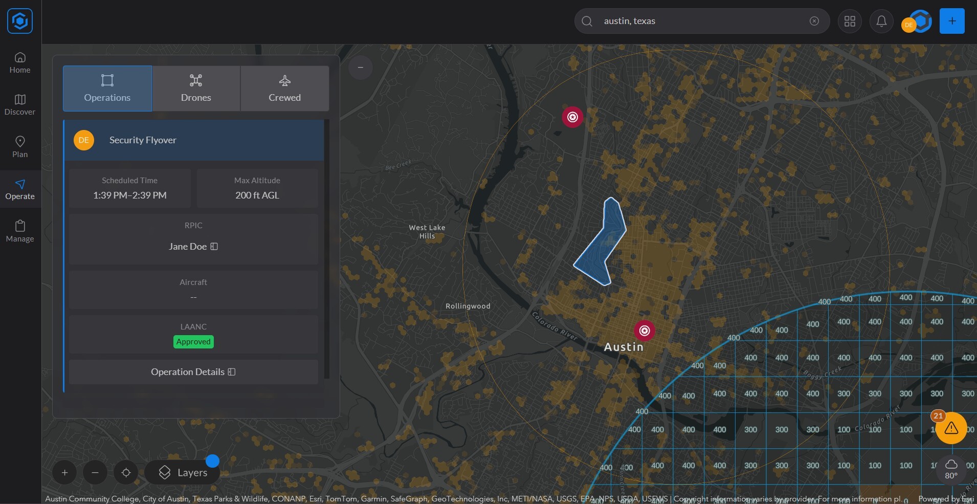
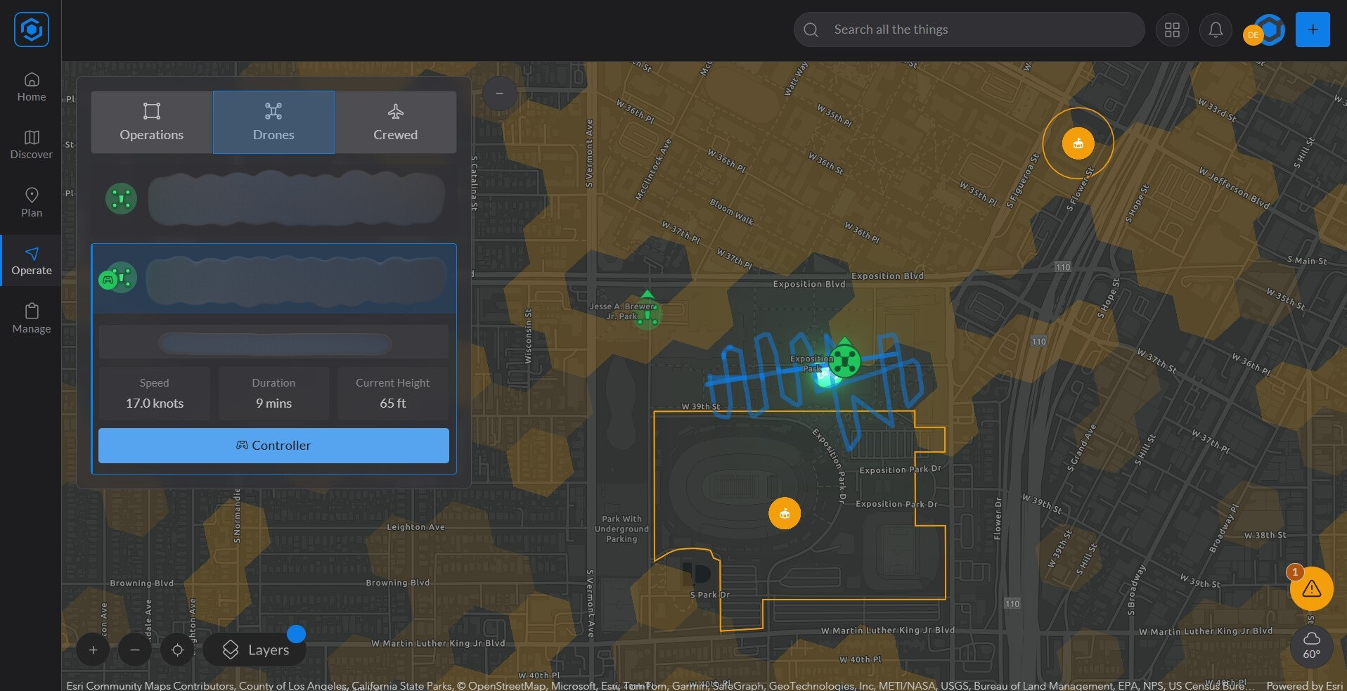
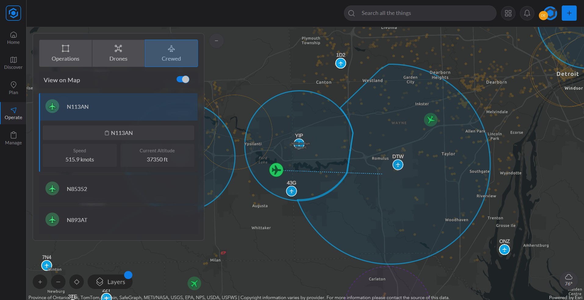
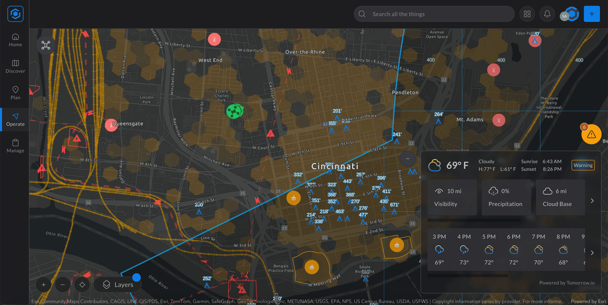
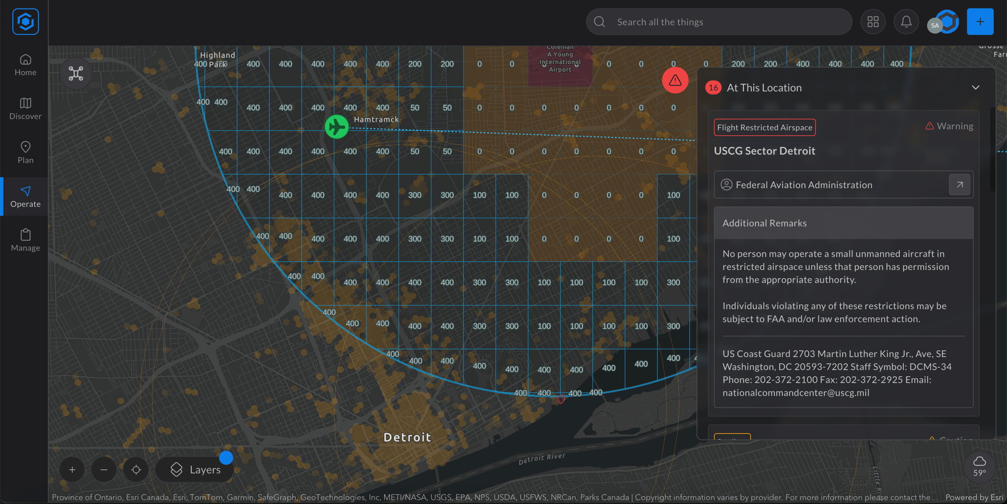
Introducing the Operations Center in AirHub® Portal
A real-time command hub that gives teams a complete view of active missions, air traffic, weather, and more—all in one place.
Active & Planned Operations
Visualize all your organization’s scheduled and in-progress drone flights for the day.
Live Drone Detection & Activity
Monitor real-time drone activity from sensor integrations across your airspace. (Advanced license required)
Live Crewed Air Traffic
Stay aware of nearby manned aircraft with real-time data from integrated crewed aviation sensors. (Advanced license required)
Weather Overlay
See current weather conditions on the map to make safer, more informed operational decisions.
B4UFLY Briefing Layer
Access FAA advisories, airspace restrictions, and more—built into your operational view.
Altera omnium vel ut. Tollit blandit consetetur pro at, liber nominati persequeris has at. Ne ludus mollis urbanitas cum. Ei veniam praesent imperdiet sea, no eum doming euismod ornatus. Ad postea invidunt omittantur sed, ne brute dolores copiosae sed. Ei vis modus nihil explicari, nam id aperiam perfecto consequuntur.
Altera omnium vel ut. Tollit blandit consetetur pro at, liber nominati persequeris has at. Ne ludus mollis urbanitas cum. Ei veniam praesent imperdiet sea, no eum doming euismod ornatus. Ad postea invidunt omittantur sed, ne brute dolores copiosae sed. Ei vis modus nihil explicari, nam id aperiam perfecto consequuntur.
Designed for Teams that Need Eyes in the Sky
Flight Operations Manager
Professionals responsible for planning, coordinating, and overseeing drone operations to ensure safe, efficient, and compliant missions.
State & Local Authorities
Government agencies tasked with monitoring airspace activity to enhance public safety, community awareness, and operational coordination within their jurisdiction.
Public Safety Agencies
Police, fire, and emergency services using drones to monitor infrastructure, manage events, and respond to emergencies with real-time airspace visibility for faster, safer decision-making.
Civilian & Defense Airfield Managers
Personnel managing both manned and unmanned airspace around airfields, ensuring safe, coordinated operations and minimizing conflicts between drones and traditional aircraft.
The Future of Drone Operations Management is Here
The new Operations Center takes AirHub® Portal to the next level—delivering real-time visibility and total operational control. From planning to approvals, airspace awareness to flight logging, it’s the all-in-one system trusted by organizations every day. Learn more about the Operations Center here.