

What the Administration's Historic Drone Executive Orders Mean for America
On Friday, President Trump signed two executive orders that will fundamentally transform how drones operate in American skies. These aren't...
1 min read
-1.png)
Airspace Link was proud to support the annual Pensacola Beach Air Show alongside partners Accipiter Radar and Seneca Nation Group, providing real-time drone operations and airspace security support to help protect one of the nation’s most iconic aviation events, featuring the Blue Angels.
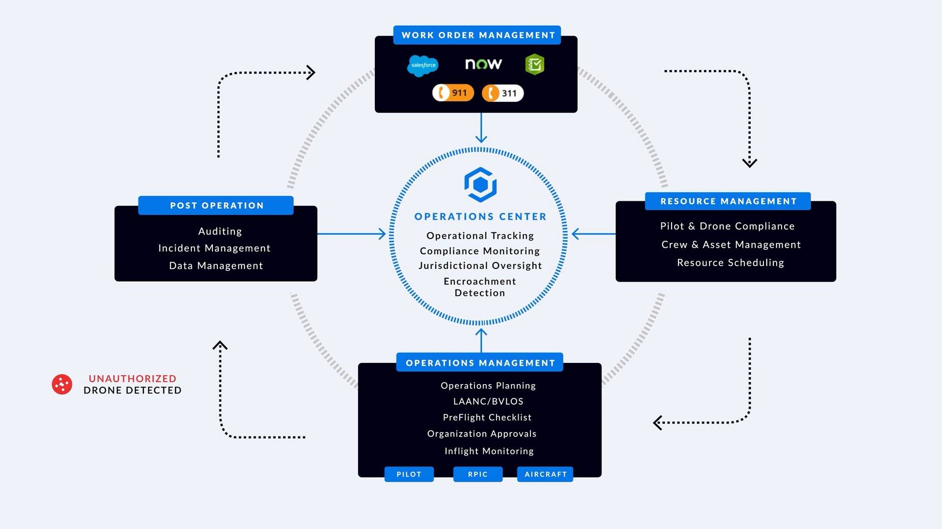
What started as a planned demonstration of our Drone Operations Management System (DOMS), AirHub® Portal, quickly became much more: a mission-critical tool used daily in the Command Center to support law enforcement, aviation authorities, and emergency response teams as they responded to real-world drone incursions during the show.
.jpeg?width=600&height=450&name=image%20(15).jpeg)
A Wake-Up Call for Airspace Awareness
Despite active FAA Temporary Flight Restrictions (TFRs) being in place, several unauthorized drones entered restricted airspace, putting participating aircraft at risk and forcing quick action from agencies on the ground. Airspace Link’s AirHub Portal used a combination of live data feeds from our partners including Accipiter Radar (RF and RID), uAvionix (ADS-B), and Esri (Live Weather and Local Data) providing command staff the capabilities necessary to quickly pinpoint drone activity, assess risk, and coordinate response.


Multiple drone interdictions occurred throughout the week. The platform’s ability to provide a real-time Common Operating Picture (COP) of both cooperative and non-cooperative aircraft gave multi-jurisdictional teams at the Federal, State, County and Municipal levels the shared situational awareness they needed to act and proved just how urgent and important proactive drone management is becoming.
A True Team Effort
This success would not have been possible without the hard work and collaboration of:
-1.png?width=600&height=450&name=image%20(7)-1.png)
Special thanks to everyone who was on the ground and whose leadership and expertise brought everything together.
Turning Lessons into Action
This event was more than a tech demo, it was a real-world test that showed how cities, counties, and agencies can start preparing today for the future of low-altitude airspace. From drone detection, alerts, operations coordination, and airspace planning, Airspace Link’s DOMS showed its value in supporting public safety when it matters most.
We look forward to continuing the after-action reviews with our partners and integrating lessons learned to further improve how communities protect their skies as drone activity continues to grow under new FAA rules like Part 108.
For more information or a demonstration of AirHub® Portal, contact our team below to see how your organization can implement a comprehensive drone operations management system (DOMS) today.


On Friday, President Trump signed two executive orders that will fundamentally transform how drones operate in American skies. These aren't...
The transformation happening above our cities is both invisible and inevitable. While most residents go about their daily routines, a quiet...
In the dynamic world of drone operations, staying informed about the ever-changing airspace is a fundamental pillar of safety, compliance, and...