
What the Administration's Historic Drone Executive Orders Mean for America
On Friday, President Trump signed two executive orders that will fundamentally transform how drones operate in American skies. These aren't...
7 min read
The transformation happening above our cities is both invisible and inevitable. While most residents go about their daily routines, a quiet revolution is taking place in the airspace just hundreds of feet overhead. Drones are already flying—inspecting aging bridge infrastructure, monitoring traffic patterns in real-time, delivering life-saving medications to underserved communities, and providing critical aerial support for emergency response teams.
But here's the challenge that's keeping city leaders awake at night: They're doing it all in silos.
Watch our video below to learn more.
In cities across America, a challenging reality is taking shape. The Fire Department has invested in search-and-rescue drones managed through their own platform. Police maintain their tactical drone program using a different platform. Meanwhile, the Parks Department is experimenting with aerial surveying for tree health assessments using their own equipment and procedures, while the Public Works department and Marketing department are starting to operate their own single drone or small fleets for inspection or photography with another set of systems and protocols.
Each department believes they're innovating. Each is solving real problems and delivering genuine value to their communities. And quite often, each has made substantial investments in their innovative drone technology. Yet collectively, they're creating a larger problem: fragmented drone operations with no unified oversight, coordination, or accountability.
The consequences of this fragmentation are more significant than most cities realize:
This isn't just an operational inefficiency—it's a growing risk in our increasingly crowded skies. And with the FAA's recent release of Part 108 BVLOS rules, that risk is about to accelerate exponentially.
In August 2025, Transportation Secretary Sean Duffy unveiled the FAA's long-awaited Part 108 Notice of Proposed Rulemaking—the comprehensive framework for Beyond Visual Line of Sight (BVLOS) drone operations. This isn't just another regulatory update. It represents the most significant transformation in urban airspace management since the advent of aviation itself.
Under these new rules, drones will soon operate routinely beyond the visual line of sight of their operators, without requiring the complex, case-by-case waivers that have historically limited commercial drone operations. The implications for cities are immediate and profound:
But here's what many cities haven't yet realized: This transformation will happen whether they're ready or not.
Commercial drone operators, delivery companies, infrastructure inspection firms, and emergency service providers are already preparing to scale their operations under these new rules. Cities that lack proper coordination systems will find themselves managing an unprecedented increase in airspace activity without the tools, processes, or visibility needed to ensure safe, efficient operations.
The solution isn't simply buying more technology or hiring more staff. What cities need is a fundamental shift in how they approach drone operations: from fragmented, departmental silos to unified, centralized management through a comprehensive Drone Operations Management System—or DOMS—such as Airspace Link’s AirHub® Portal.
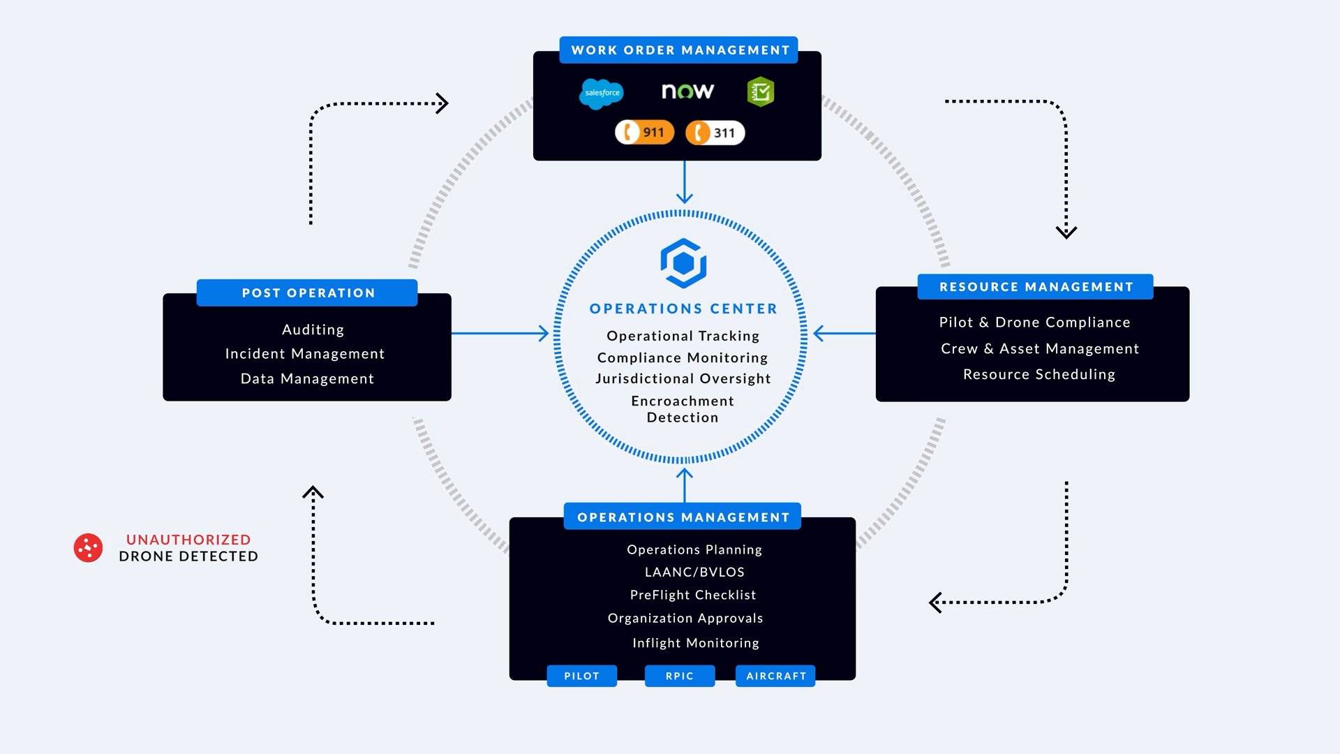
A proper DOMS isn't just software—it's a complete operational framework built around what we call the Drone Operations Lifecycle. This systematic approach ensures every drone mission, from every department, follows the same structured process that prioritizes safety, compliance, and coordination.

Work Order Management: Where Missions Begin
Requests flow in from trusted systems—ServiceNow, Esri ArcGIS Survery123, 911/311, and other 3rd party systems—and are converted into standardized drone work orders with location, priority, time window, and success criteria. From there, AirHub® Portal schedules and deconflicts automatically. A bridge inspection from Public Works, a search and rescue call from Fire, and an emergency response mission from Police now start the same way, so nothing is missed and conflicts are surfaced before they become incidents.
Resource Management: People, Aircraft, Readiness
Before any prop spins, the platform verifies pilot and aircraft compliance, aligns crew and asset availability, and performs resource scheduling across departments. Certifications, recency, maintenance intervals, and sensor fit are checked in the background, ensuring the right operator, aircraft, and payload show up to the right mission—without double-booking a team or dispatching an aircraft that’s due for service.
Operations Management: Plan, Approve, Fly
Execution is standardized from pre-flight to landing, with sophisticated flight management through operations planning, authorization handling (LAANC/BVLOS), and comprehensive pre-flight checklists—each anchored to the Operations Center’s live schedule and map. Missions are designed against air and ground constraints and the day’s active flight plan to avoid interference, then routed through the appropriate chain of command for approvals.
As flights proceed, the platform provides real-time monitoring of active missions with conflict detection, geofence/TFR awareness, and priority preemption—so an emergency launch can safely supersede routine work. If Fire deploys during a scheduled bridge inspection, the system automatically reprioritizes, notifies impacted teams, and re-times or reroutes the inspection to keep operations safe and continuous.
Post Operation Oversight: Prove Compliance, Learn, Improve
Every mission closes the loop with auditing, incident management, and data management. Flight logs, approvals, video/imagery, exceptions, and outcomes are captured automatically and rolled up to dashboards. Leaders get defensible records for regulators and councils, faster after-action reviews, and a feedback loop that continuously hardens safety and efficiency—turning every flight into program evidence, not just another sortie.
The Operations Center: Your Cities Command Center
The Operations Center is the city’s airspace nerve center. It unifies data repository, situational awareness, jurisdiction overwatch, and an optional Compliance Public Viewer so leaders—and when appropriate, residents—see what’s flying, where, and why. Every stage of the lifecycle reads from and writes back to this hub, giving the city one authoritative picture instead of scattered snapshots.
Managing your own drone operations is only half the equation. As urban airspace becomes increasingly crowded with both authorized and unauthorized drone activity, cities need comprehensive visibility into all drone traffic above their communities—not just their own operations.
A complete Drone Operations Management System must incorporate advanced drone detection and identification capabilities that provide real-time awareness of unauthorized drones, aircraft flying illegally or in violation of airspace requirements, and potential security threats that could endanger public safety or critical infrastructure. This includes:
Real-Time Drone Detection through integrated radar and sensor data creates a comprehensive picture of all aerial activity above your city. This isn't just about tracking your own fleet—it's about identifying unknown aircraft that may pose risks to public events, government facilities, airports, or emergency operations.
Automated Threat Assessment distinguishes between authorized commercial operations, legitimate recreational flights, and potentially problematic activity. When delivery drones are operating normally along approved corridors while an unidentified aircraft appears near a stadium during a major event, the system immediately flags the anomaly for investigation.
TFR Violation Monitoring becomes critical as Temporary Flight Restrictions are issued for everything from presidential visits to major public events. A comprehensive system tracks active TFRs and immediately identifies any drone activity that violates these restrictions, enabling rapid law enforcement response before situations escalate.
Single Pane of Glass Operations integrate all elements—your own drone operations, detected external traffic, airspace restrictions, weather conditions, and security alerts—into one unified display that gives city leadership complete situational awareness of their airspace environment.
This capability is particularly crucial for public safety operations. When police deploy tactical drones during an emergency response, they need to know immediately if unauthorized aircraft are operating in the same area. When fire departments are conducting search-and-rescue operations, they must be aware of any conflicting traffic that could interfere with their missions or create safety hazards.
The security implications extend beyond immediate safety concerns. Cities host major events, protect critical infrastructure, and maintain government facilities that could be targets for malicious drone activity. A comprehensive drone detection system provides the early warning capabilities needed to respond to potential threats before they can impact public safety or security.
As BVLOS operations scale dramatically under the new Part 108 rules, this comprehensive airspace awareness becomes even more essential. Cities that can only see their own operations will be flying blind to the broader airspace picture—unable to coordinate with external operators, identify security threats, or maintain the complete situational awareness needed for safe, efficient urban drone integration.
Cities face a critical decision point. The next 18 months represent a competitive advantage window that will determine which communities thrive in the new drone economy and which fall behind.
Early Adopters who implement comprehensive drone operations management systems now will attract new businesses, capture federal funding opportunities, improve emergency response capabilities, and enhance public services while establishing themselves as innovation leaders.
Late Adopters who wait until BVLOS operations become routine will find themselves managing increased airspace complexity without proper systems, scrambling to establish coordination protocols under pressure, competing for limited implementation resources, and potentially facing safety incidents that could set back their drone programs for years.
The economic implications extend far beyond operational efficiency. Cities with robust drone operation frameworks will become magnets for logistics companies, infrastructure inspection firms, emergency service providers, and the growing ecosystem of drone-related businesses. Meanwhile, communities without proper coordination systems risk becoming less competitive for both business investment and federal funding opportunities.
The transformation of urban airspace is no longer a future scenario—it's happening now. With Part 108 BVLOS rules establishing the regulatory framework for routine drone operations, cities have a narrow window to establish the systems, processes, and coordination capabilities they'll need to manage this transformation safely and effectively.
Airspace Link's AirHub® Platform provides the comprehensive drone operations management system that cities need to navigate this transition successfully. As the established air traffic control system for drones, our platform already manages over 100,000 monthly users across 6,000 unique businesses and government agencies.
Our platform delivers the complete Drone Operations Lifecycle framework—from integrated planning and resource management to real-time monitoring and comprehensive oversight. More importantly, it provides city leadership with the operational visibility, regulatory compliance, and coordination capabilities needed to manage the most significant transformation in urban airspace since the original invention of aviation.
The skies over your city are changing forever. The question isn't whether drone operations will scale dramatically in your community—it's whether your city will be ready to manage that transformation safely, efficiently, and to your community's advantage.
Your city. Your skies. Connected.
Ready to learn more about how Airspace Link can help your community prepare for the drone transformation? Contact our team at marketing@airspacelink.com, or click on the button below to discuss your city's drone operations management needs.


On Friday, President Trump signed two executive orders that will fundamentally transform how drones operate in American skies. These aren't...

Earlier this month, President Trump signed two executive orders that will fundamentally transform the skies above all American cities. Under these...
SUMMARY: Unmanned Aircraft System Traffic Management (UTM) is complicated. Government agencies are uninformed, under-equipped, and underprepared....