
The Sky Above Your City Just Changed Forever: Your 120-Day Drone Readiness Action Plan
Earlier this month, President Trump signed two executive orders that will fundamentally transform the skies above all American cities. Under these...
2 min read

The counter-UAS market is moving fast. With FIFA World Cup 2026 driving procurement timelines across 11 U.S. host cities, agencies are investing heavily in detection systems — radar, RF sensors, acoustic arrays. But detection alone answers only half the question. When a sensor flags an unknown aircraft over a packed stadium, someone still has to answer the most critical question in real-time: is that drone friend or foe? Without operational control, everything looks like a threat.
The operational layer cities are adding to complete their C-UAS architecture.
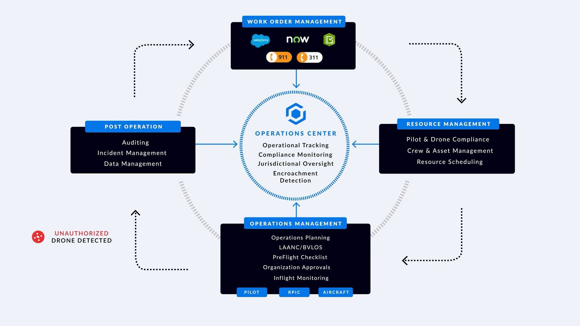
Most C-UAS deployments focus on detection (radar, RF sensors, acoustic systems) and mitigation (authorized countermeasures). Between these two critical capabilities sits a third essential function: identification and coordination.
Without unified visibility, operators manually cross-reference multiple dashboards during live incidents—C-UAS vendor interfaces, fleet management systems, authorization lists, and radio communications with neighboring jurisdictions.
During time-sensitive security events, those minutes matter.
Urban airspace is more complex than detection vendors can address alone.
On any given day during major events, C-UAS sensors detect multiple aircraft simultaneously:
Police drones on patrol or emergency response
Fire department drones assessing damage
Commercial delivery drones (Amazon, Zipline, Wing)
News helicopters covering events
Recreational pilots in unrestricted airspace
Unauthorized drones (no threat)
Actual hostile actors requiring mitigation
The operational challenge: distinguishing authorized operations from potential threats in real-time.

AirHub Portal dashboard showing Identification Friend or Foe (IFF) technology that allows registration of friendly or approved drones (blue drones.)
Deploying response drones to investigate threats multiplies operational complexity.
Launching response drones for visual identification is often the fastest way to assess unknown aircraft and locate operators. But now C-UAS sensors are tracking multiple objects.
When sensors flag an unknown drone approaching secured perimeters, operators need immediate answers:
Authorized aircraft from a known operator?
Our own response drone launched to investigate?
Genuine threat requiring mitigation?
This is the critical operational layer that transforms detection into security.
Vendor-agnostic coordination that sits between detection and mitigation.
.png?width=928&height=773&name=Home%20Page%20AirHub%20Portal%20(1).png)
Aggregates data from all C-UAS sensors, fleet management systems, authorized operators, and airspace users into single operational view.
Instant friend-or-foe determination across all sensors, operators, and agencies.
Coordinates deployment of response drones while tracking detected threats.
Works with any C-UAS sensor vendor, any fleet management system, any authorized operator.
Defensible documentation for every operational decision and coordination action.
The system facilitates seamless coordination across different agencies and jurisdictional boundaries, ensuring all stakeholders maintain awareness of drone activities that may affect their operations.

Kansas City is building its C-UAS architecture for FIFA World Cup 2026 matches at Arrowhead Stadium. AirHub Portal will serve as the coordination layer — integrating sensor data with fleet management, neighboring agencies, and FAA airspace information to provide unified friend-or-foe determination and response drone coordination across Missouri and Kansas.

Federal installations and critical infrastructure sites deploy integrated C-UAS detection with unified coordination systems to track all airspace activity, coordinate response drones when threats are detected, and maintain complete operational awareness across multiple agencies and sensor vendors.

Law enforcement agencies coordinate C-UAS operations across city, county, and state boundaries while managing their own DFR programs, ensuring instant identification of all airspace users to distinguish authorized aircraft from potential threats during time-sensitive incidents and major events.
Detection tells you something is there. Mitigation gives you the ability to act. But without the identification and coordination layer in between, operators are making high-stakes decisions with incomplete information. AirHub Portal fills that gap — giving your team unified situational awareness across every sensor, every agency, and every authorized operator in your airspace. Contact us to see how it works.

Earlier this month, President Trump signed two executive orders that will fundamentally transform the skies above all American cities. Under these...

Application Deadline: December 5, 2025, 5:00 PM ET; Full $500 Million Program to Support All U.S. Cities in Building Drone Security Infrastructure
The transformation happening above our cities is both invisible and inevitable. While most residents go about their daily routines, a quiet...